
A dangerous wave of wildfires is spreading across the tropics, and the Amazon rainforest is now facing a growing crisis. Fueled by severe drought linked to El Niño, fires are sweeping through parts of Brazil, filling cities with smoke and threatening forests already damaged by previous fire seasons.
Unlike tornadoes or thunderstorms, which can cause widespread destruction in a matter of minutes, El Niño influences weather patterns over many months. The climate phenomenon can disrupt rainfall across vast regions, creating unusually dry conditions that allow fires to spread rapidly. Scientists warn that the Amazon may be entering the beginning of a prolonged and destructive fire season.
NASA Satellites Detect Surging Amazon Wildfires
Beginning in September 2026, satellite observations revealed a sharp increase in fires and smoke emissions across the central and eastern Amazon. The growing activity appeared in several monitoring systems, including NASA’s Fire Information for Resource Management System (FIRMS), the Global Fire Emissions Database (GFED), and NASA Worldview.
The affected area extends from the forests surrounding Manaus and Santarém, two major commercial and transportation hubs in Brazil, eastward toward the mouth of the Amazon River.
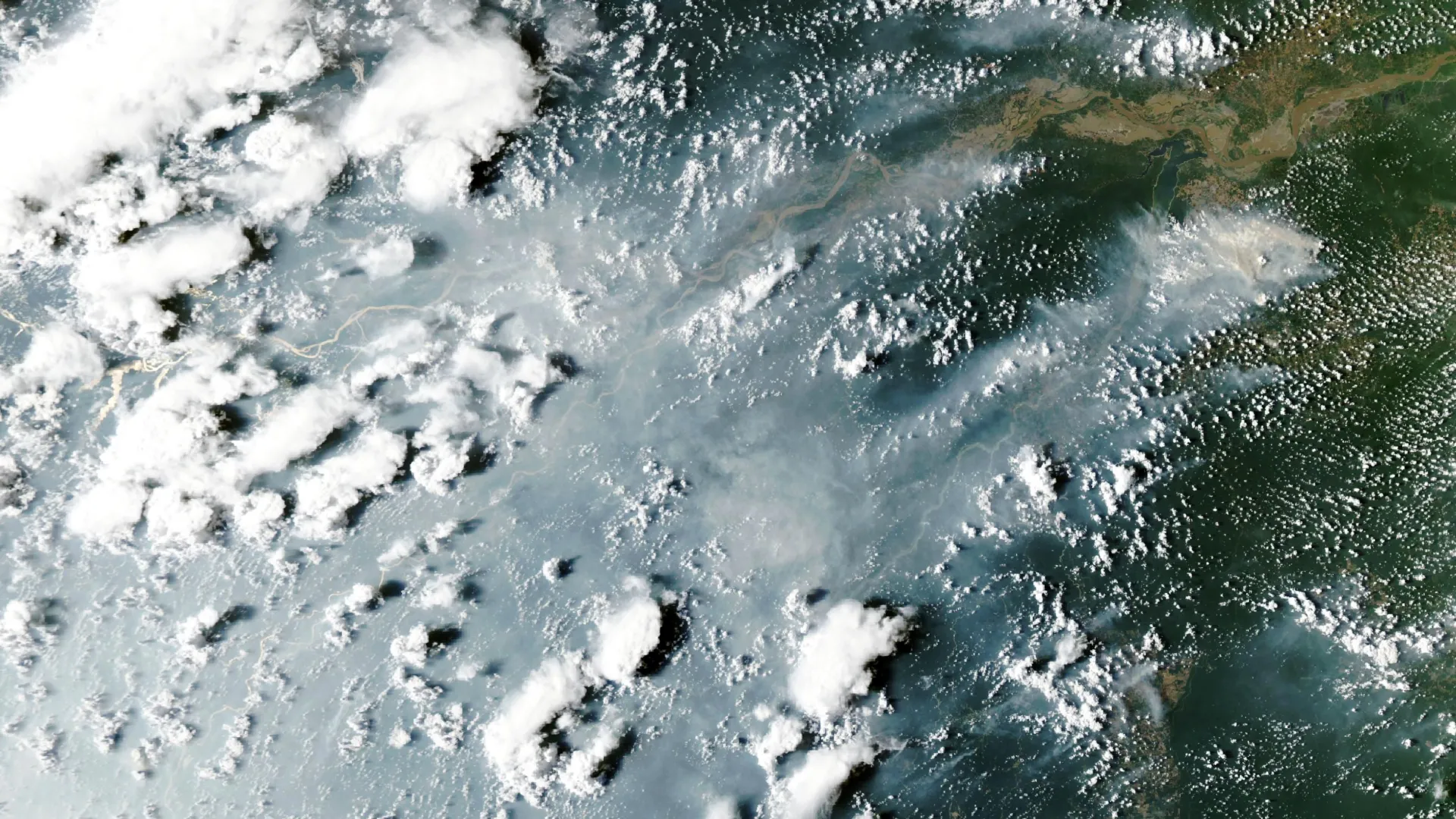
On October 12, 2026, the MODIS (Moderate Resolution Imaging Spectroradiometer) instrument aboard NASA’s Aqua satellite captured an image showing enormous plumes of smoke rising from fires on both sides of the Amazon River.
At the time, thick smoke had engulfed Manaus, the capital of Brazil’s Amazonas state. City officials reported dangerously polluted air, with concentrations of fine particulate matter (PM2.5) exceeding 135 micrograms per cubic meter. These microscopic particles can penetrate deep into the lungs and pose serious health risks. The measurements placed the city’s air quality in the second-worst category of a regional air quality index.
The smoke brought major disruptions to Manaus, which is home to more than 2 million people. Schools shut down, public events were canceled, and children’s sports leagues suspended activities as authorities warned residents about hazardous conditions, according to news reports.
El Niño Is Triggering a Wildfire Domino Effect
According to Douglas Morton, an Earth system scientist at NASA’s Goddard Space Flight Center, the fires surrounding Manaus and Santarém are part of a much larger pattern.
Morton describes the phenomenon as a “cascade” of tropical fires driven by rainfall disruptions associated with El Niño. The sequence typically begins near the equator, where drought helps ignite peat fires in Indonesia. These fires burn through carbon-rich organic material in the soil. As dry conditions develop elsewhere, fire activity intensifies in the central and eastern Amazon.
This pattern is not new. Following the devastating 2015-2016 El Niño, Morton worked with scientists from the University of California, Irvine; Vrije Universiteit Amsterdam; and the University of Maryland to examine how tropical fires followed shifting rainfall patterns. Their findings were published in a 2017 study. Researchers observed a similar sequence in 2023.
Now, the 2026 El Niño appears to be producing the same progression.
Indonesia has already experienced months of drought, smoke, and destructive fires beginning in August. During October, wildfires destroyed hundreds of homes, while dense smoke covered entire islands on most days.
“Now, in the Amazon, we’re seeing the second domino in the cascade fall,” Morton said, referring to the increasing number of fires in the Brazilian states of Pará and Amazonas.
Scientists Warn More Fires Could Spread Into 2027
The current surge may be only one stage of a much longer fire season.
Morton and his colleagues anticipate that fire activity will expand northward during November and December 2026. The regions at risk include the Brazilian states of Roraima and Amapá, northern Pará, and portions of Venezuela, Guyana, and Suriname.
The pattern is then expected to shift southward. By August and September 2027, drought conditions and wildfire danger could reach their highest levels in the southern Amazon regions of Brazil and Paraguay.
One particularly troubling aspect of the current crisis is that many of the threatened forests have burned before.
“It’s so striking — and frustrating — that this is happening all over again,” said Morton, noting that forests affected by the 2015 and 2023 El Niño events are once again catching fire.
Wildfires are especially destructive in tropical rainforests because most of the plants and animals living there have not evolved to withstand frequent burning. Unlike ecosystems where fire is a regular natural process, Amazon forests can suffer severe and lasting damage when flames move through them.
Previous fires have also left parts of the forest more vulnerable. Trees partially burned during earlier events may be weakened or damaged, making the remaining vegetation more susceptible to future fires. Morton warned that some of the current blazes could therefore burn more intensely than before.
He expects fires near Manaus and Santarém to persist until seasonal rains return, likely in December 2026 or January 2027.
However, communities in regions farther north and south still have an opportunity to reduce the danger before conditions deteriorate.
“Given the intensity of this El Niño, this really is the year for people to avoid burning at all costs,” Morton said.
Extreme Drought Turns Human-Started Fires Into Wildfires
Although the Amazon is experiencing a severe fire emergency, lightning is rarely responsible for igniting fires in Brazil’s rainforest.
The region is normally so wet that lightning causes less than 1 percent of fires, according to Morton. This means that nearly all of the fires currently spreading through the Brazilian Amazon originated from human activity.
What makes 2026 particularly dangerous is the severity of the drought.
Brazil’s National Institute of Meteorology reported that rainfall in Manaus was 95 percent below normal in August and 60 percent below normal in September.
These extremely dry conditions have transformed fires that might otherwise have remained confined to managed areas into uncontrolled wildfires.
Morton explained that many of the larger blazes began as deliberately set fires used for land management, such as removing shrubs from grazing land or clearing crop residue from fields. Once the flames escaped, they spread into the rainforest’s parched understory, the layer of vegetation growing beneath the taller trees.
Satellite analysis suggests that approximately 50 to 70 uncontrolled fires are currently burning in the Santarém area alone, according to Shane Coffield, an assistant research scientist at the University of Maryland who works at NASA Goddard.
NASA Uncovers Hidden Fires That Satellites Are Missing
The actual number of Amazon wildfires may be substantially higher than standard satellite monitoring systems indicate.
As part of a NASA Earth Action project, Coffield is studying observations collected by VIIRS (Visible Infrared Imaging Radiometer Suite), a satellite instrument capable of detecting heat signatures associated with active fires.
His goal is to identify fires that fail to meet the detection requirements used in official FIRMS data products.
These additional detections, known as “candidate fires,” could help researchers develop a more complete picture of wildfire activity. Coffield plans to provide their locations to MapBiomas, a collaborative network of universities, nongovernmental organizations, and technology companies that tracks fires and changes in land use throughout the Amazon.
The initial findings suggest that conventional monitoring is overlooking a significant number of blazes.
“For the area around Santarém, we’ve identified about 40 percent more fires than you’ll see in active fire counts from FIRMS,” said Coffield.
Detecting fires beneath a rainforest canopy can be surprisingly difficult, even with sophisticated instruments in orbit. Satellite sensors identify wildfires by measuring infrared radiation, which reveals the heat generated by burning vegetation.
However, thick smoke, persistent cloud cover, and dense tree canopies can interfere with those measurements. Fires that burn slowly through the understory are particularly difficult to detect because the vegetation above them can conceal their heat signatures.
As a result, satellite fire counts may sometimes fall even when extensive burning continues on the ground.
“On some of the smokiest days, we have very few detections from MODIS and VIIRS, and we know that isn’t right.”
By identifying fires that existing monitoring systems overlook, NASA researchers hope to provide scientists and land managers with a more accurate understanding of the threats facing the Amazon as the El Niño-driven fire season unfolds.

